The world’s most populous countries, India and China are certainly headed for an all out war! In today’s post, I will attempt to explain why I think so and also explain a little of the historical context that has led to this point.
Sharing a 3500km long border separated by the Himalayan Mountain Range, Both India and China arrived on the World stage as fully independent entities after 1950. India had shaken off British occupation and declared itself a Republic while the Communists had finally united China into a unified republic again after a period of almost 100 years in the wilderness. Both countries were woefully underdeveloped and most certainly not in a position to defend their territory as effectively as the colonial masters had done. The potential for conflict always existed due to the differing perceptions on the Borders drawn by the departing Colonial Powers however the presence of the Himalayan Range and the lack of technology and resources at the time did serve as a deterrent. Not enough though, ‘cos the 2 countries did go to war in 1962 that ended in a humiliating defeat for India. india lost over 4200 soldiers and 38000 sq kms of territory in a swift war that ended as soon as it began! Since then, the Chinese have popped up intermittently laying claim to more and more Territory on the Indian side. In the last few years since Modi became PM, the Chinese have become emboldened and begun more regular incursions as they take on a more aggressive India. 2018 saw the Doklam incident, in 2019, the Indian Army discovered 26 Patrolling Points (PP) in Ladakh have been lost to the Chinese and in 2020, the 2 soldiers on both sides came to blows killing 20 soldiers on each side. Chinese have never just picked up their guns and gone to war! That has not happened in recent history. Every war is preceded by an increasing frequency of small scale incursions and carefully planned “salami slicing” – Monthly, then weekly and then followed up with an all out war. They are carefully shaping the border in preparation for maximum impact in case of a war. The average frequency of Chinese incursions has gone up from about once in 4 years before 2014 to weekly in 2018 to almost daily now! This is certainly the first indicator that China is preparing for a full blown war!
2020-Current
The Pangong Lake is a high-altitude endorheic Lake split between India and China. Roughly 20% of the lake is on the Ladakh(Indian) side while 80% of the Lake falls within Chinese Territory. Before 2020, Indian troops would regularly patrol upto a point called Finger 8/9 on the Lake (see Map and Terrain Photo below). On 5 May 2020 however, Indian Troops on Patrol were stopped at Finger 4 by Chinese Troops. The Indians discovered that in the Winter season of the previous year when Patrols had not happened, the Chinese had built substantial infrastructure like pucca roads and even Tent Camps all the way upto Finger 4. In these terrifying heights of 5kms+, It is typical to stop patrolling in the winter months of 7/8 months/year. All patrols stop around Nov and troops on both sides withdraw to their winter posts and resume patrolling when the snows begin thawing around April/May. The Chinese had used this period to build substantial infrastructure between Fingers 9 and upto Finger 4. On 5 May, the troops on both sides got into a violent confrontation for the first time since Doklam in 2018.
In late May 2020, the 2 sides clashed in Galwan when Indian troops attempted to stop a Chinese Party of engineers from upgrading infrastructure in the Valley. It was all out melee warfare (since use of arms is prohibited based on a 1996 treaty), throwing Rocks and soldiers off cliffs. Over 20 Indian troops lost their lives in the ensuing melee. On 30 August, Indian Troops fired shots at the Chinese for the first time since 1972, ratcheting up tensions. On 7th September shots were fired from both sides in Hot Springs(Gogra) and Depsang sectors. In the Depsang area, Satellite photos revealed that Chinese had managed to build up huge radar and accomodation facilities within 500m of a tactically critical PP potentially allowing them to cut off traffic on the sensitive DBO -Shyok access road and thus threaten Indian occupation of Siachen Glacier and Depsang Plains. Many Twitter accounts were barred in India for 3 months for posting these explosive pictures! The year before that, the last Chinese post was 23kms behind this sensitive Y-junction! The Indians had been caught napping and it was embarassing politically for the ruling dispensation in India which had made loud noises about putting China in its place!
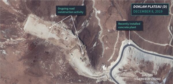
It was not like the Chinese were sitting quietly on other fronts. 2000kms away, the Chinese had rapidly built up infrastructure in the Doklam/Sikkim area. Satellite maps revealed, that after being blocked by Indian Troops at Doklam, the Chinese had simply bypassed the Doklam area to build access roads upto Gyemochen area. When the Indians withdrew from the Doklam area temporarily, the Chinese returned in force to build further roads in the area. This sector is crucial as it overlooks the Siliguri Corridor or “Chickens-Neck” – a mere 17km wide Corridor that links the disputed North Eastern states to the rest of India. The Chinese also upgraded infrastructure across the border front here from Siliguri to Arunachal (which the Chinese call Zangnan province) and built & settled 2 dozen villages deep inside what Indians claim as their territory in Arunachal/Zangnan.
In summary, the entire border/LAC is disputed but the uneasy calm that existed for over 60 years has been shattered and the 2 countries are most certainly drifting towards war!
Contd on Next Page – Why a war is Likely!


 Please wait...